-
Welcome to CivilWarTalk, a forum about the American Civil War! - Join today! It's fast, simple, and FREE!
You are using an out of date browser. It may not display this or other websites correctly.
You should upgrade or use an alternative browser.
You should upgrade or use an alternative browser.
Vicksburg Bluffs
- Thread starter Forrest
- Start date

7th Mississippi Infantry
Brev. Brig. Gen'l
- Joined
- Sep 28, 2013
- Location
- Southwest Mississippi
The wiki article is somewhat misleading. What's left of the old basin model is overgrown. You can see it's state of deterioration back in 2010 at the Urban Decay site:
http://worldofdecay.blogspot.com/2010/01/mississippi-river-basin-model-jackson.html
On a side note, the Mississippi River Basin model was built by German POW's during World War II.
http://worldofdecay.blogspot.com/2010/01/mississippi-river-basin-model-jackson.html
On a side note, the Mississippi River Basin model was built by German POW's during World War II.
Last edited:
7th Mississippi Infantry
Brev. Brig. Gen'l
- Joined
- Sep 28, 2013
- Location
- Southwest Mississippi
Not like it used to . . .That's fascinating. Jackson must have some clout and/or dough
Last edited:

Forrest
Sergeant
- Joined
- Sep 25, 2015
I have driven that stretch from Atlanta to Monroe, LA too many times to count - all before I knew my ancestor fought at Vicksburg. Leisurely drives with plenty of time to explore, unaware of all the history along that routeNot like it used to . . .

Now I am 3000 miles away.
Forrest
Sergeant
- Joined
- Sep 25, 2015
This is my best attempt at guesstimating where the rifle pits, etc, were located for the 'Depot Battery'. I have enhanced a map of the works which doesn't show the houses as well as other maps, but otherwise seems fairly accurate. On the other hand, I don't know how accurate their mapping of the rifle pits and cannon emplacement is. I do know that there should be a house just above the circle at the far right, which represents where the 10" Columbiad was located. That house is also shown in the photograph. So I know that part is correct, but that's about it!
The Depot itself is a very odd building - the ground was sloped right up to the point where I have Madison terminating, then you had the railroad yard which was flat, then it sloped up again to Washington Street. I am fairly sure that the building just behind the word 'Oak' is the mostly-destroyed building shown in the back view photo of the Depot that is shown in Championhilz' book, and shown in the map to the right, which portrays it inaccurately. You can sort of see (perhaps it is my imagination) the boards angling up and to the left from the roof. Grant's Headquarters is on the hill at the extreme right, which is also where the battery containing 'Whistling Dick' was located.
Any help in clarifying this would be greatly appreciated.

The Depot itself is a very odd building - the ground was sloped right up to the point where I have Madison terminating, then you had the railroad yard which was flat, then it sloped up again to Washington Street. I am fairly sure that the building just behind the word 'Oak' is the mostly-destroyed building shown in the back view photo of the Depot that is shown in Championhilz' book, and shown in the map to the right, which portrays it inaccurately. You can sort of see (perhaps it is my imagination) the boards angling up and to the left from the roof. Grant's Headquarters is on the hill at the extreme right, which is also where the battery containing 'Whistling Dick' was located.
Any help in clarifying this would be greatly appreciated.
- Joined
- Mar 20, 2014
Does anyone have any photos or drawings of the bluffs in front of Vicksburg when the Mississippi was low? At the risk of sounding dumb, was it possible for supplies to get into Vicksburg via the Mississippi when the bluffs were exposed to their full heights? All the photos and drawings I've found have shown the buildings at water level, except one poor engraving that seems to show them at about 20 feet - still, even in that one there is a steam boat at the landing. Thanks.
Mother nature with the Mississippi Flood of 1876 and more extensively The Great Mississippi Flood of 1927 totally changed the Big Muddy after which it has not lapped the shores of Vicksburg, since 1876.
These floods accomplished what eventually is referred to as, "Grant's Canal" tried but failed to do, economically and militarily isolate Vicksburg. The original idea was contemplated late June 1862 Farragut / Porter and 3000 of General Williams troops and then slaves when the river was low the weather was hot, disease rampant, and the idea abandoned.
As Johan and TinCan posted the water passing Vicksburg now was dug by the US Army Corp of Engineers, 1903.
There are excellent videos on the Vicksburg Campaign posted to YouTube taken by Karl Stelly while on extensive (multiple days, total over 9 hrs, traveling and explaining all the way down to Ft Wade, Grand Gulf, Port Gibson, then to Raymond, Champion's Hill, etc then back to Vicksburg) tours with the Louisville Civil War Round Table by the NPS and Vicksburg Military Park filmed in 2003 (pre Katrina) The guide was Terry Winschel, Historian at the Vicksburg National Military Park.
Sorry just meant to post the link to YouTube not the video here. I do not know how to change it. I think there are a total of 9 videos. Enjoy! BGB
Winschell is very detailed and shows and explains the change in the river, level of water at various time including the rise and fall while the Grant Canal was being dug and then the river swamping it.
He also discusses the placement and the elevation of guns.
He would be a great direct source of info, maps and photos if not retired. If retired he would probably be thrilled to get a phone call requesting a discussion of his expertise.
Another YouTube of David Bastian, a retired Corp of Engineers Hydrologist (formally based in Vicksburg who wrote a book on the subject). The presentation was for Chicago CW Round Table (May 2014). He discusses the history of the River (from 1858) as it relates directly to "Grant's Canal" informative but. . . He discusses the depth of the river at different times of year (i.e. " . river still high and fast when Farragut and Porter reach Vicksburg May 18, 1862 and then the river is lower by late June 1862).
He has interesting trivia and comments re; the river, depths, bars, current, eddies etc. His book probably has photos and maps. I have not pursued it.
I hope this helps.
I found the detail, explanation and maps, of the Vicksburg Campaign videos, and on site views fascinating. I watched them slowly over a couple of weeks. They gave me continued perspective of my limited but growing knowledge on the subject.
I also had a relative who fought at Vicksburg.
Attachments

Last edited:
7th Mississippi Infantry
Brev. Brig. Gen'l
- Joined
- Sep 28, 2013
- Location
- Southwest Mississippi
@BlueGrayBlood , Thanks !
I know this will be an enjoyable series. I'm looking forward to watching all of these videos.
I know this will be an enjoyable series. I'm looking forward to watching all of these videos.
- Joined
- Mar 20, 2014
Your best bet would be to find Terry Winschel (Vicksburger posted that he met and spoke with him)I've looked at the original photo for hours, comparing it to battery/trench locations in period maps as well. If you look at how the red line follows Pearl street, going through the houses at the right, I believe the batteries,etc are just behind those houses. I was initially confused about this, as it would restrict the line of sight, but that entire block is not only on the edge of the bluff, but is still very steep going up from Pearl to the the Depot and on through to the rail yard on the other side of the Depot, where it flattens out. The rail yard is the only flat space in that area, as the terrain angles up again to Washington Street. The Depot itself is much taller on the River side, than on the rail yard side - this can be seen in another photo of the Depot and rail yard that was taken from the southeast. Given all that, the houses could provide some masking, but the guns could still probably fire over them, so best of both worlds. I would love to hear opinions, as this is all speculation.
Call the Vicksburg NMP in Vicksburg. Terry is the Vicksburg "man" (historian) for info, maps and photos, etc
Last edited:
- Joined
- Mar 20, 2014
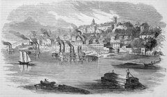
Wiki . . . Vicksburg from 1855Does anyone have any photos or drawings of the bluffs in front of Vicksburg when the Mississippi was low? At the risk of sounding dumb, was it possible for supplies to get into Vicksburg via the Mississippi when the bluffs were exposed to their full heights? All the photos and drawings I've found have shown the buildings at water level, except one poor engraving that seems to show them at about 20 feet - still, even in that one there is a steam boat at the landing. Thanks.
Attachments
- Joined
- Mar 20, 2014
7th Miss Inf@BlueGrayBlood , Thanks !
I know this will be an enjoyable series. I'm looking forward to watching all of these videos.
It is very informative
Sad part it was raining throughout most of the tour video
Enjoy
BGB
Forrest
Sergeant
- Joined
- Sep 25, 2015
Your best bet would be to find Terry Winschel (Vicksburger posted that he met and spoke with him)
Call the Vicksburg NMP in Vicksburg. Terry is the Vicksburg "man" (historian) for info, maps and photos, etc
Thanks for the tip. If all goes as planned, I will be visiting Vicksburg this summer - I need to make it a very 'efficient' trip, so I will definitely do as you suggest.
Forrest
Sergeant
- Joined
- Sep 25, 2015
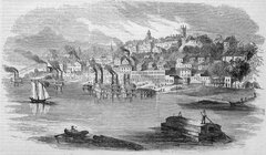
Wiki . . . Vicksburg from 1855

I don't for the life of me understand why the Civil War era engravings are so inaccurate - this is a beautiful engraving, showing Sky Parlor Hill (just to the right of the square steeple), and even the train depot and bluff in front of it; however, that section (with the depot) is extremely inaccurate - it shows no houses in the blocks below it, and a line of buildings along the waterfront that did not exist. It's as if the artists drew pictures from memory, aiming for a good 'feel' for the city. They generally only got the courthouse, Catholic church, castle and Sky Parlor Hill correct, filling in the rest with whatever looked good to them.
Attachments

Vicksburger
First Sergeant
- Joined
- Dec 16, 2011
- Location
- Saint Joseph
Forrest: You're doing some great detective work. I will be following your conclusions closely. You may have to make some of your investigations on the ground when you are there this summer. Ask the visitors center for Terry Winschell's phone number, he is very cooperative and may have some inside info. Also, have you thought about looking at the files at the VMP, (if they allow that), for any old maps showing where batteries were?This is my best attempt at guesstimating where the rifle pits, etc, were located for the 'Depot Battery'. I have enhanced a map of the works which doesn't show the houses as well as other maps, but otherwise seems fairly accurate. On the other hand, I don't know how accurate their mapping of the rifle pits and cannon emplacement is. I do know that there should be a house just above the circle at the far right, which represents where the 10" Columbiad was located. That house is also shown in the photograph. So I know that part is correct, but that's about it!
The Depot itself is a very odd building - the ground was sloped right up to the point where I have Madison terminating, then you had the railroad yard which was flat, then it sloped up again to Washington Street. I am fairly sure that the building just behind the word 'Oak' is the mostly-destroyed building shown in the back view photo of the Depot that is shown in Championhilz' book, and shown in the map to the right, which portrays it inaccurately. You can sort of see (perhaps it is my imagination) the boards angling up and to the left from the roof. Grant's Headquarters is on the hill at the extreme right, which is also where the battery containing 'Whistling Dick' was located.
Any help in clarifying this would be greatly appreciated.
View attachment 90956
Vicksburger
First Sergeant
- Joined
- Dec 16, 2011
- Location
- Saint Joseph
Forrest, is the depot building the big building with white sides, with the smoke stacks going in front of it?This is my best attempt at guesstimating where the rifle pits, etc, were located for the 'Depot Battery'. I have enhanced a map of the works which doesn't show the houses as well as other maps, but otherwise seems fairly accurate. On the other hand, I don't know how accurate their mapping of the rifle pits and cannon emplacement is. I do know that there should be a house just above the circle at the far right, which represents where the 10" Columbiad was located. That house is also shown in the photograph. So I know that part is correct, but that's about it!
The Depot itself is a very odd building - the ground was sloped right up to the point where I have Madison terminating, then you had the railroad yard which was flat, then it sloped up again to Washington Street. I am fairly sure that the building just behind the word 'Oak' is the mostly-destroyed building shown in the back view photo of the Depot that is shown in Championhilz' book, and shown in the map to the right, which portrays it inaccurately. You can sort of see (perhaps it is my imagination) the boards angling up and to the left from the roof. Grant's Headquarters is on the hill at the extreme right, which is also where the battery containing 'Whistling Dick' was located.
Any help in clarifying this would be greatly appreciated.
View attachment 90956

jack1492
Corporal
- Joined
- May 9, 2014
- Location
- Sunny South
Some excellent photos and maps posted here.
jack1492
Corporal
- Joined
- May 9, 2014
- Location
- Sunny South
Oh, one thing that may be useful is the Tulane University, Howard-Tilton Memorial Library has a very large and detailed topographical map of Vicksburg. I had nice photos of it but lost them when my cell phone crashed a while back. I forget the year the government created the map but early 1900s I think. This map may help with your project and other libraries have it too, I am sure.
Forrest
Sergeant
- Joined
- Sep 25, 2015
Oh, one thing that may be useful is the Tulane University, Howard-Tilton Memorial Library has a very large and detailed topographical map of Vicksburg. I had nice photos of it but lost them when my cell phone crashed a while back. I forget the year the government created the map but early 1900s I think. This map may help with your project and other libraries have it too, I am sure.
There are some gigantic ones on the loc site as well - some are not very easy to find with searches. A forum member provided the link to the one shown here (with trench details).
Forrest, is the depot building the big building with white sides, with the smoke stacks going in front of it?
Yes, it is. This is only the second photographic view of the Depot that I have seen - even though I knew exactly where it had been located, etching images of that area were so inaccurate that I could not recognize depictions of the depot. Now I'm finding that the depot is actually represented in many period etchings - it just doesn't look much like it should.
jack1492
Corporal
- Joined
- May 9, 2014
- Location
- Sunny South
No, never.Did confederates ever attempt to recapture Vicksburg? Or at least plan to?
- Joined
- Mar 20, 2014
www.nps.gov/vick or by calling 601-636-0583. They will know how to contact Terry Winschel
Forrest: You have already completed a lot of shoe leather research call him now and tell him of your pending trip and he can guide you to further info, photos and maps you desire to prep for your trip. Fascinating, keep us posted.
"On Friday, January 15, 2016, the Mississippi River at Vicksburg crested at 8:00 am at 50.23 feet. This will place it ninth among historic crests. The 2011 flood crested at 57.1 feet. Major flood stage is 50 feet at Vicksburg. The flood did not impact any area of Vicksburg National Military Park."
Remember this is the Yazoo River cut by the Army Corp.
https://www.facebook.com/vicksburgnmp.nps post a query, never know, like here, what will pop up.
Forrest, 7th Miss Inf., Vicksburger, et al :
There are a lot of LBGT videos (no not that PC nonsense, "Licensed Battlefield Guide Training" Seminar)
this one is on Vicksburg Geography and Topography is pretty basic but shows a slide (at~ 19 min) on an era Topo map ? at Vicksburg Have not found the source. If you can find it, this may help you discern elevations and distance from river front. A lot better than the glam shot etchings.
www.youtube.com/vicksburgnmp see video list.
I like the military / political perspectives of Brig Gen (Retired) Parker Hills, presentations, 2014 Vicksburg campaign series and one in 2008.
I don't recall if he discussed the exact height from the river water level, of the bluffs, etc. but good info & trivia. He does show the current and circa 1862 river path on maps for viewing perspective.
Forrest: sounds like you have a mission and plenty of time to prep before your 3000 mile trek.
Warning this is all quicksand....BGB
Forrest: You have already completed a lot of shoe leather research call him now and tell him of your pending trip and he can guide you to further info, photos and maps you desire to prep for your trip. Fascinating, keep us posted.
"On Friday, January 15, 2016, the Mississippi River at Vicksburg crested at 8:00 am at 50.23 feet. This will place it ninth among historic crests. The 2011 flood crested at 57.1 feet. Major flood stage is 50 feet at Vicksburg. The flood did not impact any area of Vicksburg National Military Park."
Remember this is the Yazoo River cut by the Army Corp.
https://www.facebook.com/vicksburgnmp.nps post a query, never know, like here, what will pop up.
Forrest, 7th Miss Inf., Vicksburger, et al :
There are a lot of LBGT videos (no not that PC nonsense, "Licensed Battlefield Guide Training" Seminar)
www.youtube.com/vicksburgnmp see video list.
I like the military / political perspectives of Brig Gen (Retired) Parker Hills, presentations, 2014 Vicksburg campaign series and one in 2008.
I don't recall if he discussed the exact height from the river water level, of the bluffs, etc. but good info & trivia. He does show the current and circa 1862 river path on maps for viewing perspective.
Forrest: sounds like you have a mission and plenty of time to prep before your 3000 mile trek.
Warning this is all quicksand....BGB
Similar threads
- Replies
- 8
- Views
- 53

- Replies
- 6
- Views
- 614

- Replies
- 65
- Views
- 2K

- Replies
- 16
- Views
- 416

Similar threads
- Replies
- 11
- Views
- 12

- Replies
- 19
- Views
- 20
- Learn About Us
- ►About CivilWarTalk
- ►Contact the Webmaster
- ►Meet the Staff
- ►Link to CivilWarTalk
- Join Our Community
- ►Register
- ►Browse Forums
- ►View Today's Discussions
- ►Search the Forum
- Get Help
- ►FAQ
- ►Student Guide
- ►Forum Rules & Etiquette
- ►Copyright / DMCA
 Bringing the