Willoughby Run from the other side.

infomanpa

1st Lieutenant
Joined
Feb 18, 2017
Location
Pennsylvania
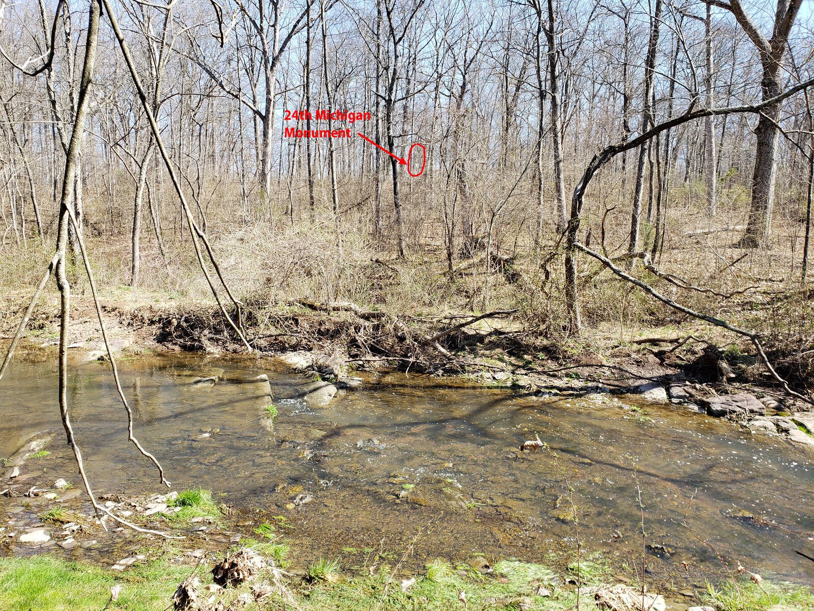
Finally found a nice trail (actually a public sewer access) on the west bank of Willoughby Run at Gettysburg. Like most tourists, I had only been on the east bank. It was nice to get a view from the perspective of both Archer's and Pettigrew's brigades before they splashed across this stream on the first day of battle.

This first picture shows the quarry, front and center.
20210330_110553.jpg


In this second picture, you can see the monument to the 24th Michigan on the crest of the ridge. Of course, you would have no chance of seeing it once the leaves are on the trees.
Will.jpg
 
I walked around that area a few years back and was surprised to see how little of water there was in the creek.. The book I had read described it as knee to waist deep as the Confederates splashed through to cross it.
I agree that it's pretty shallow. I examined the creek for a good length and despite a heavy rainfall a couple days earlier, I could have crossed it and never gotten wet above the knees. In fact, I almost found a spot where I could have crossed by stepping on rocks. I guess it's possible that the creek's source tributaries have been modified due to development?
 
I would love to find that spot. My antecedent Pvt. Y.K. Brown was captured there. Part of Archers Brigade, 13th Alabama, Co H.

He spent the rest of the war as a POW at Ft. Delaware, Pea Patch Island. Until paroled sometime, I believe in '65 upon taking the Oath.
 
Note the Lithia Springs were apparently another name for the Emanuel Harmon farm springs

NPS MUseum . Willoughby's Run between Lithia Springs and the spot where Gen. Reynolds fell. (1860s-1870s).
 
Last edited:
see the following links of willoughby Run and emmanuel Harman farm
 
In geetysburg Journal IN Time" a more extensive view of tyson picture

If it was taken in the creek between the springs and site of reynolds death....the woods in the background could only be McPhersons woods...
 
Finally found a nice trail (actually a public sewer access) on the west bank of Willoughby Run at Gettysburg. Like most tourists, I had only been on the east bank. It was nice to get a view from the perspective of both Archer's and Pettigrew's brigades before they splashed across this stream on the first day of battle.

This first picture shows the quarry, front and center.
View attachment 396007

In this second picture, you can see the monument to the 24th Michigan on the crest of the ridge. Of course, you would have no chance of seeing it once the leaves are on the trees.
View attachment 396008
Thanks for posting - you're right, I've only seen it from the east - amazing what a change in perspective can do!
 

Learn About Us
About CivilWarTalk
Contact the Webmaster
Meet the Staff
Link to CivilWarTalk
Join Our Community
Register
Browse Forums
View Today's Discussions
Search the Forum
Get Help
FAQ
Student Guide
Forum Rules & Etiquette
Copyright / DMCA

     Contact Us CivilwarTalk on Facebook CivilWarTalk on YouTube CivilWarTalk on Twitter RSS Feed

Bringing the American Civil War and More to Life.
© 1999 - , CIVILWARTALK, LLC - Site Version 10.0

SlaveryTalk.com - SecessionTalk.com - CivilWarTalk.com - ReconstructionTalk.com
Back
Top