Washington Navy Yard

Mark F. Jenkins

Colonel
Member of the Year
Joined
Mar 31, 2012
Location
Central Ohio
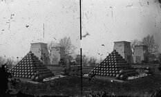
I found this on the curator's photostream of the National Museum of the U.S. Navy (thanks, AndyHall, for pointing it out)...

Something I find odd about it are the structures in the background. They are clearly 'Egyptianizing' architecture, that is, designed in ancient Egyptian style-- in this case, somewhat like a 'pylon' temple gateway. It gives the shot 'pyramid' a whole 'nother meaning...

The caption states that this was 'probably' at the Washington Navy Yard.
 

Attachments

  • LC-DIG-CWPBH-03346_ProbablyWashingtonNavyYd.jpg
    LC-DIG-CWPBH-03346_ProbablyWashingtonNavyYd.jpg
    2.6 MB · Views: 318
Agreed. The location is definitely questionable.

I notice that in the right rear one can make out a bit of a "roundhouse," which was a structure shared among several Navy Yards and stations (Brooklyn and Mound City among them), and often used as a sort of personnel office. I'm not clear on how the octagonal structure became traditional for that use, but it seems to have.
 
This looks to be taken from near the same position during the war and the identity of Washington Navy Yard is pretty good for it:

washington%2Bnavy%2Byard%2Bartillery.jpg


I believe it was uploaded to LOC fairly recently.

Source.
 
I don't recall that image, but it doesn't look like the Washington Navy Yard to me. CW-era images of the yard don't seem to show many trees, or elevation of the terrain. E.g.,

Expired Image Removed

The photographs could be from a section of the waterfront (which I believe could be beyond the large dry dock building on the left) which has a very interesting park of historical artillery to this day in front of the museum there. The building where the shooting happened a few years ago is very close to this park as well.
 
View attachment 66269
Here's what I think might be the earliest photograph of the Washington Navy Yard in 1850. Lots of trees, but it looks like a lot of buildings were added in the intervening years.

Source.

I don't believe this is the Navy Yard. It looks like a picture of Greenleaf Point, looking southeast from Hains Point. The body of water in the foreground is Washington Channel. The river that cuts up to the left in the pic is the Anacostia at its confluence with the Potomac. The Anacostia Hills are in the background. The Navy Yard is nearly a mile "around the corner" and up the Anacostia from the photographer's vantage point.

I think this is a period picture of Ft. Leslie McNair. The U.S. Army War College sits today about where the buildings to the left in the pic are. The large structure on the right is gone.
 
That certainly would explain the large artillery park, anyway. And those don't look like boat howitzers... not to mention, they have limbers, which boat howitzers typically lacked.
 
I don't believe this is the Navy Yard. It looks like a picture of Greenleaf Point, looking southeast from Hains Point. The body of water in the foreground is Washington Channel. The river that cuts up to the left in the pic is the Anacostia at its confluence with the Potomac. The Anacostia Hills are in the background. The Navy Yard is nearly a mile "around the corner" and up the Anacostia from the photographer's vantage point.

I think this is a period picture of Ft. Leslie McNair. The U.S. Army War College sits today about where the buildings to the left in the pic are. The large structure on the right is gone.

Yeah, I think you are right, the terrain makes much more sense. I never questioned the "U.S. Navy Yard" identification as being other than the Washington Navy Yard as I didn't think there would be the large dry dock building at a waterfront army base in DC.
 
navy yard map.jpg


Another possibility explaining the smaller body of water in the foreground and the larger expanse in the background of that image could be explained by this 1855 map actually with the arrow pointing in the direction from where the photograph was taken. The rectangular building in the southwest of the Navy Yard would match up perfectly with the location of the dry dock building. It looks like a lot of the water in the foreground visible in the photograph is filled in today.
 
Maybe, but there's really no reason for a bunch of field artillery to be at the Navy Yard, and every reason to be at the Arsenal. I think that's most likely a solid ID.
 
View attachment 66276

Another possibility explaining the smaller body of water in the foreground and the larger expanse in the background of that image could be explained by this 1855 map actually with the arrow pointing in the direction from where the photograph was taken. The rectangular building in the southwest of the Navy Yard would match up perfectly with the location of the dry dock building. It looks like a lot of the water in the foreground visible in the photograph is filled in today.

It's possible, but the distances from Hains Point, passed Greenleaf to the the East Bank of the Anacostia is perfect. The Anacostia River at the Navy Yard is not that wide.
 
Hey, I just got notified I've made 1st Lieutenant in this thread. I'll try not to spend all the money in one place!
 
Maybe, but there's really no reason for a bunch of field artillery to be at the Navy Yard, and every reason to be at the Arsenal. I think that's most likely a solid ID.

I was talking about the 1850 photograph I posted regarding the map, sorry for any confusion.
 

Learn About Us
About CivilWarTalk
Contact the Webmaster
Meet the Staff
Link to CivilWarTalk
Join Our Community
Register
Browse Forums
View Today's Discussions
Search the Forum
Get Help
FAQ
Student Guide
Forum Rules & Etiquette
Copyright / DMCA

     Contact Us CivilwarTalk on Facebook CivilWarTalk on YouTube CivilWarTalk on Twitter RSS Feed

Bringing the American Civil War and More to Life.
© 1999 - , CIVILWARTALK, LLC - Site Version 10.0

SlaveryTalk.com - SecessionTalk.com - CivilWarTalk.com - ReconstructionTalk.com
Back
Top