Map Identification Help, Please

DaveBrt

1st Lieutenant
Joined
Mar 6, 2010
Location
Charlotte, NC
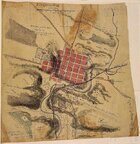
I found this map on Flickr and really need to find the original in order to get a more legible copy and to get permission to publish. Can anyone help me locate the original?
 

Attachments

  • Martinsburgmap httpsc2.staticflickr.com21141778489029_1a5a002ddc_z.jpgzz=1.jpg
    Martinsburgmap httpsc2.staticflickr.com21141778489029_1a5a002ddc_z.jpgzz=1.jpg
    137.8 KB · Views: 161
Bottom left corner notes the approval of James W. Abert, Captain U.S. Army (?) And dated in 1861. Captain Abert served as a topographical engineer in the Regular Army and on the staff of Generals Robert Patterson and Nathaniel Banks early in the War. I would suggest starting with the Official Records.
 
There is a similar, Confederate map by Hotchkiss in the OR Atlas, Plate XXXII, No. 2:

Expired Image Removed
 

Learn About Us
About CivilWarTalk
Contact the Webmaster
Meet the Staff
Link to CivilWarTalk
Join Our Community
Register
Browse Forums
View Today's Discussions
Search the Forum
Get Help
FAQ
Student Guide
Forum Rules & Etiquette
Copyright / DMCA

     Contact Us CivilwarTalk on Facebook CivilWarTalk on YouTube CivilWarTalk on Twitter RSS Feed

Bringing the American Civil War and More to Life.
© 1999 - , CIVILWARTALK, LLC - Site Version 10.0

SlaveryTalk.com - SecessionTalk.com - CivilWarTalk.com - ReconstructionTalk.com
Back
Top