Transportation Revolution

@kevikens

1972

Sir, couldn't agree more - however, Agnes was a once in 100 year storm. (for the central PA area) Lived through it. That would not be the real threat.

In this proposed timeline, the bridges would have went down in July. Back up soon after. The real yearly threat to any expediently re-build cross-river structure would have been the next year's spring thaw / flood. Huge broken pieces of ice flowing down river at speed and slamming into bridge supports have been the epitaph of more than one south central PA bridge.

For a long term solution, it would have to be re-built almost immediately out of sterner stuff, unless like the above pic - the stone casements were re-used as supports.

Cheers,
USS ALASKA
 
Last edited:
Depends on what you mean by "completely shut down." When Jackson broke the line in June 1861, the connection between western Virginia and Washington, D. C. remained broken for 10 months.
Did the Union forces have corp or divisions of engineers? By the end of the first two years were they not able to repair the rails faster than because the system carried the necessary rails and equipment for repair where the Confederacy lacked these item and the labor to accomplish this correct?, These engineers would be the same ones who would lay out the Transcontinental rail system .Suggest read; David McCollum ' s history of the construction of the Transcontinental
 
An interesting visual of rail growth between 1850 and 1860...notice Ohio / Indiana / Illinois - Indiana did not lack for access. I wonder if the governor's comments on demanding the Mississippi be re-opened were just public grandstanding for the benefit of his constituents...

emmaandjason123_1394112390.jpg


https://s3-eu-west-1.amazonaws.com/infogram-particles-700/emmaandjason123_1394112390.jpg

Cheers,
USS ALASKA
 
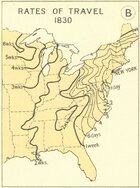
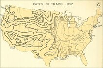
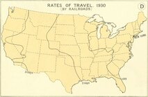
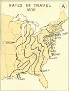
Found a very interesting representation of travel rates during different time periods. Graphically shows the effect of the 'Transportation Revolution'

Railroad Travel Rates, 1800-1930
This series of maps from the 1932 Atlas of the Historical Geography of the United States shows the progressive decrease in travel time by depicting the time required to travel from New York to various western locations in 1800, 1830, 1857, AND 1930.


rail.str.0241.01.jpg


rail.str.0241.02.jpg


rail.str.0241.03.jpg


rail.str.0241.04.jpg


About this Document

  • Source: Atlas of the Historical Geography of the United States
  • Author: Charles O. Paullin and John K. Wright
  • Publisher: Carnegie Institute of Washington and the American Geographical Society of New York
  • Published: Washington, D.C.
  • Citation: page 138a, b, c, and d
  • Date: 1932
http://railroads.unl.edu/documents/view_document.php?rends[]=map&id=rail.str.0241

888

Cheers,
USS ALASKA
 

Attachments

  • rail.str.0241.01.jpg
    rail.str.0241.01.jpg
    133.8 KB · Views: 102
  • rail.str.0241.02.jpg
    rail.str.0241.02.jpg
    134.2 KB · Views: 100
  • rail.str.0241.03.jpg
    rail.str.0241.03.jpg
    80.2 KB · Views: 110
  • rail.str.0241.04.jpg
    rail.str.0241.04.jpg
    61 KB · Views: 106
Cambridge University Press
JOURNAL ARTICLE
The Transportation Revolution and Antebellum Sectional Disagreement
John J. Binder
Social Science History
Vol. 35, No. 1 (Spring 2011), pp. 19-57 (39 pages)
Published by: Cambridge University Press


ABSTRACT
The transportation revolution had several important effects on the antebellum political equilibrium. First, it caused western and southern political views to differ by bringing more easterners and European immigrants into the West. Second, it reduced the costs of rerouting western exports to the non-South, which decreased the expected costs to the West of conflict with the South. Third, it greatly increased western population, which brought more free states into the Union and changed the balance in the Senate. Fourth, it increased northern numerical superiority over the South, giving the North a major advantage if an armed conflict did occur. These changes led the West to ally with the East and caused the South to secede.

Full article on JSTOR, with Google sign-in (if you have a Gmail account, you have a Google sign-in and this will allow for free reading of 100 articles a month).

Cheers,
USS ALASKA
 
Cambridge University Press
JOURNAL ARTICLE
The Transportation Revolution and Antebellum Sectional Disagreement
John J. Binder
Social Science History
Vol. 35, No. 1 (Spring 2011), pp. 19-57 (39 pages)
Published by: Cambridge University Press


ABSTRACT
The transportation revolution had several important effects on the antebellum political equilibrium. First, it caused western and southern political views to differ by bringing more easterners and European immigrants into the West. Second, it reduced the costs of rerouting western exports to the non-South, which decreased the expected costs to the West of conflict with the South. Third, it greatly increased western population, which brought more free states into the Union and changed the balance in the Senate. Fourth, it increased northern numerical superiority over the South, giving the North a major advantage if an armed conflict did occur. These changes led the West to ally with the East and caused the South to secede.

Full article on JSTOR, with Google sign-in (if you have a Gmail account, you have a Google sign-in and this will allow for free reading of 100 articles a month).

Cheers,
USS ALASKA

I don't know about this. Indiana Governor Oliver Morton wrote Lincoln, purportedly speaking for the governors of the Old Northwest, that they would secede and join the Southern Confederacy, if Lincoln could not gain control of navigation upon the Mississippi River. Morton was not even subtle about it.

Whatever the "transportation revolution" was, it hadn't satisfied the upper Mid-West that they should "ally with the East."
 
Another paper to go with this thread...


Cheers,
USS ALASKA
 
Understood sir, however while the Susquehanna can be considered a 'mighty' river, many caveats need to be used.

It is the longest river on the East coast.

It is the 16th-largest river in the United States.

It is the longest river in the United States without commercial boat traffic...

...because while being very wide at certain points, it is also very shallow.

To repair any damage caused by Confederate raiders, we aren't talking about this...

View attachment 174317

we are talking about this...

View attachment 174318

There are times in the summer you can walk across without getting your knees wet.

It would not be that big of a deal, construction wise, to restore traffic service with no adversarial forces around.

I've been around the river since 1970 and crossed over it in the Harrisburg area every day for 25 years. Done a lot of river recreation in these very areas. In the railroad bridge locations, it just isn't very deep, fast flowing, or treacherous - just wide

Cheers,
USS ALASKA
To bolster you're point, there's a six foot dam about a mile or so downstream of the HT bridge where your modern photo was taken that wasn't there during the CW.
 
JOURNAL ARTICLE
On the Use of Geographic Information Systems in Economic History: The American Transportation Revolution Revisited
Jeremy Atack
The Journal of Economic History
Vol. 73, No. 2 (JUNE 2013), pp. 313-338 (26 pages)
Cambridge University Press

Transportation improvements in the nineteenth century loom large in the historiography of the profession during the twentieth century. This article describes the ongoing construction of a historical geographic information systems (GIS) transportation database designed to provide new insights into the impact of the transportation and communications revolution in the continental United States by providing evidence on the spatial dimensions of those changes over time. It also reviews some preliminary findings and reinterpretations based upon these data.


Full article at above link on JSTOR with Google sign-in (In the upper right-hand corner of the linked page, there is a 'Log in' button. If you have a Gmail account, you have a Google sign-in and this will allow for free reading of 100 articles a month).

Cheers,
USS ALASKA
 
JOURNAL ARTICLE
Steam Transport, Sovereignty, and Empire in North America, circa 1850–1885
JAY SEXTON
Journal of the Civil War Era
Vol. 7, No. 4, Crises of Sovereignty in the 1860s: A Special Issue (DECEMBER 2017), pp. 620-647 (28 pages)
University of North Carolina Press

1714688884254.png


Full article at above link on JSTOR with Google sign-in (In the upper right-hand corner of the linked page, there is a 'Log in' button. If you have a Gmail account, you have a Google sign-in and this will allow for free reading of 100 articles a month).

Cheers,
USS ALASKA
 
1731536294486.png

American Rail Network 1861

Sources: Railroads and the Making of Modern America, University of Nebraska, Lincoln (Rail Network). US Census Bureau (Urban Population).

In only 30 years after its introduction, the American rail network totaled about 28,900 miles (46,500 km) on the eve of the Civil War (1861-1865). Yet, the American rail network was composed of two systems reflecting the political division between the North (Union States) and the South (Confederate States). Outside a connection through Washington, the networks were disconnected and serviced different economic systems. This lack of connectivity was compounded by the fact that railways servicing the same city were often not connected, requiring ferrying cargo from one terminal to the other and for passengers to spend a night to catch the next day train (schedules were not effectively coordinated).

The dominantly rural society of the South was mainly serviced by penetration lines seeking to connect the agricultural hinterland to ports where surpluses were exported (e.g. New Orleans & Charleston). As such, the network was not very cohesive. The more urbanized North developed a network that interconnected its main urban centers and agricultural regions in the Midwest in a complex lattice. At the end of the Civil War, the expansion of the network would resume, as well as its level of integration.


Cheers,
USS ALASKA
 
SPECIAL HISTORY STUDY
THE EVOLUTION OF TRANSPORTATION IN WESTERN PENNSYLVANIA
May 1994
United States Department of the Interior
National Park Service

Communication and Transportation Routes, 1810-1836 31
Rivers, Canals, and Railroads, 1825-1840 59
Major Railroads in Western Pennsylvania, ca. 1860-1930 95

The Southwestern Pennsylvania Heritage Preservation Commission requested the completion of a special history study of transportation in western Pennsylvania in November of 1992. The commission hoped that such a study would enhance an understanding of the motives for transportation development in the region, the evolution of transportation technology as it responded to western Pennsylvania's distinctive geography, and the impact of transportation development on the region's social, political, and economic history. A special study would provide a broad historical context to enhance and complement other planning efforts either currently in progress or those that may be undertaken in the future. The study would also provide additional data for the sites that interpret western Pennsylvania's history. The study is currently organized in four segments that address early trails and roads, canals and river transport, railroads, and roads and highways. Much of the data in the third section on railroads was provided by the Department of Applied History at Carnegie-Mellon University. The examination of the technological aspects of railroading by Carnegie-Mellon University leaves room for some additional work on the railroads' impact on western Pennsylvania society and politics. The development of transportation in western Pennsylvania provides important insights into the essential human desire to establish some control over the environment. It illuminates the vital role of the state, whether on the federal, commonwealth, or local level, in creating transportation improvements, and to a remarkable degree, in directing the course of economic development. The region's history also offers important evidence of the impact that transportation networks can have on the evolution of politics and society. From trails to roads, to turnpikes and canals, to railroads and highways, the pattern has remained remarkably unaltered. Human activity and the landscape of western Pennsylvania have combined to form a distinctive chapter in American history.


File too large to attach, please use above link.

Cheers,
USS ALASKA
 
What the map does not show is the gauges of those lines - the distance between the rails. The British and European standard was 4ft 8½ inches - 'standard gauge'. Much of the network shown in N America was of the same gauge , but there were some differences, particularly in the South, with a 5-foot gauge, plus some at 5'6" and, in NY state, 6'. There was also alot of 'narrow gauge' lines around 3'
The problem? Large changes in gauge required a change of locomotive AND carriage or wagon. Some wagons had 'extra' wheels or wheels that could be moved, but moving takes time -and cost a lot more. Some had wider wheels to take in an inch in difference, but they did not wear well as there was a lot of movement across the tire (in contact with the rail) and on the flange (the bit that keeps it on the rail). In 1860, there were at least 11 distinct railroad track gauges in use in the northern states alone. A train trip from Philadelphia to Charleston required 8 changes of car because of differences in track width.

Memphis was blessed with three gauges - standard (from the North), 5' (from the South) and 5'6" (from the West). Standard gauge was standardised by Congress in 1886, allowing a two-day changeover.

** Note: The standard gauge of 4ft 8½in was NOT decided by 'Roman chariot wheels'. George Stephenson worked in the North East of England where the standard internal colliery track was around 4'8" which fitted the width of the mine passages and adits. Since these lines used steam engines on the surface, that was the gauge he used. It was the same gauge for the first public railway - the Stockton and Darlington (1825). There was a problem on some of the curves reported in built-up areas where the wagons squealed around the tighter curves, caused by the flanges on the wheels and the camber of the track, so Stephenson added an extra half-inch which solved the problem.
 

Learn About Us
About CivilWarTalk
Contact the Webmaster
Meet the Staff
Link to CivilWarTalk
Join Our Community
Register
Browse Forums
View Today's Discussions
Search the Forum
Get Help
FAQ
Student Guide
Forum Rules & Etiquette
Copyright / DMCA

     Contact Us CivilwarTalk on Facebook CivilWarTalk on YouTube CivilWarTalk on Twitter RSS Feed

Bringing the American Civil War and More to Life.
© 1999 - , CIVILWARTALK, LLC - Site Version 10.0

SlaveryTalk.com - SecessionTalk.com - CivilWarTalk.com - ReconstructionTalk.com
Back
Top