Hello all,
I'm planning a day trip this weekend to the Battle of South Mountain (Md.) site, and was hoping to call on the experiences and insight of CWT folk.
I have a general familiarity with the battle and also a fine battlefield guide that I borrowed from the Enoch Pratt Free Library (Antietam, South Mountain & Harpers Ferry: A Battlefield Guide by Ethan S. Rafuse, University of Nebraska Press, 2008). But maybe there is something special I should keep my eye out for? or a little known by-way that might be interesting to explore?
I'm particularly interested in locating the positions of Roswell's Brigade (CSA) and the 3rd North Carolina in the fighting at Fox's Gap, as part of my ongoing research into the history of the 3rd NC. Mt wife's great great grandfather, Lt. George Washington Ward, was a veteran of this battle, as well as of Antietam, and many others.
Best,
Bruce
I live very close to Fox's Gap. In fact, I'm looking at it through my home office window right now. If you visit the gap, there's a dairy farm at the end of Reno Monument road that has a creamery where they serve ice cream made on the premises. We had a preservation march about 6 years ago and couldn't resist stopping there before ascending the mountain. It was funny to see all the reenactors lounging around eating ice cream cones.
Below is a map of the parking area at Fox's Gap showing the location of the Wise farmhouse and the dry well where they dumped the dead Confederates after the battle (X marks the spot). The well has been excavated and sealed over to prevent scavenging and the bodies were relocated long ago, but it's still eerie to park there and know you're just a few feet away from the scene of that grisly incident. The large square to the right is Reno's monument and the 17th Michigan field is across the street from that.
Here's a postcard from 1909 that shows the farmhouse still standing on the far right in what is now the parking area. You can see Reno Monument on the left.
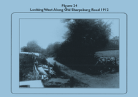
Here's another postcard from 1912 looking west along the Sharpsburg Rd.
Finally, here is a
Walking Tour of the gap that you could follow and a link to a Google map that show the exact location of the stops on the tour:
https://www.google.com/maps/d/viewer?ll=39.468568,-77.618666&spn=0.011595,0.018239&hl=en&t=h&msa=0&z=15&source=embed&ie=UTF8&mid=1YPxq9xPraArNwGmxU2sASef2USY
Parking area: This was the site of the Wise's farm. A log house was located in the back end of the parking area. Across Reno Monument Road is a trail with a Green sign to the 17th Michigan. This is the Wood Road that continues to Turners Gap one mile to the north. The Appalachian trail follows the Wood Road. To the east across the service road was a four acre field, known as Wise's Field. It extended south about 500 feet (near the modern gate on the service road), and east along the road for several hundred feet. The service road closely follows a historic Ridge Road that traveled south along the ridge. The fields to the south closely resemble their historic size.
Most of the battlefield is private property. Please obey all signs.
Follow the service road one mile south to the location of the power line.
Stop 1: On the morning of September 14th, this was the position of the 5th North Carolina. The left flank of the Confederate line rested about a half mile farther to the south, with the 5th Virginia Cavalry, along with Pelham's section anchoring the line.
Around 9:00AM in the morning the lead elements of the IX corps moving up the Loop road about 1/2 mile to the east began to arrive on the field. The first regiment to deploy was the 23rd Ohio of the Kanawha Division deploying in the southeast corner of the field. The 5th NC advanced to a stone wall midway in the field (just past the crest of the hill to your front) and engaged the 23rd Ohio. Lt Col. Rutherford Hayes of the 23rd Ohio was wounded early in the fighting near the location of the power line tower in the southeast corner of the field (a better view of this area is seen from Stop 2). With the arrival of the 11th Ohio, the 5th North Carolina was forced to retire from the field. Lt. Col Hayes would survive his wound and the war. In 1876 he was elected President of the United States.
Follow the service road back north 1/10 mile.
Stop 2: The road at this point was filled with Artillery wagons and caissons. In the field to your right was the position of Bondurant's four gun battery. The guns were facing in a southeast direction towards the power line tower (the site of Lt. Col. Hayes wounding). With the defeat of the 5th NC to the south, the Ohio troops were able to gain position of the stone wall separating this field and the one to the south. With the enemy now on his flank, Bondurant's Battery began withdrawing his guns from right to left, with each gun changing direction to face the enemy, firing one round, limbering up, and then withdrawing to the north.
Continue north 1/2 mile. There is a side trail on your right that will go to the North Carolina monument.
Stop 3: This is the near the center of the first Confederate line facing east, under the command of General Samuel Garland. To the east were the Federal regiments of the Kanawha Division. From 10:00 to 10:30 in the morning, fighting raged in the fields to your front, often in hand to hand combat. By 10:30 the Federals were successful in driving the Confederates in front of them down the western side of the mountain. The Federals changed direction facing to the north and advanced towards the remaining Confederate defenders near the Wise farm. The 30th and 36th Ohio to the east of the road and the 12th and 11th Ohio to the west of the Ridge Road.
Continue north 4/10 mile.
Stop 4: Near this spot General Garland was talking to Lt. Col. Ruffin of the 13th North Carolina. Ruffin was wounded in the hip, and as Garland turned to shout at an orderly, he was hit in the chest. Garland was carried by the Wood Road to the South Mountain Inn one mile to the north. He bled to death later in the day. By noon the remaining Confederates were driven from this area, and the Federals took a defensive position at the south end of Wise's field.
Cross the road and enter the field. Turn right (east) and follow the north side of the road 100 feet.
Stop 5: By 3:00PM Drayton's Brigade arrived on the field. Drayton had initially deployed his brigade in an inverted L-shaped formation at the gap. The 550 men in his two South Carolina units were in the Old Sharpsburg Road facing south and the 750 soldiers in the three Georgia units were posted facing east at a stone wall overlooking a deep ravine some 200 yards east of the Wood Road. At 4:00PM Col. Drayton ordered his three veteran regiments to attack the Federals to the south. His two new regiments, the 50th and 51st Georgia, moved into the sunken road, also facing south to offer support. What Drayton did not know was that Orlando Willcox's 3,600 man IX Corps division had arrived on the field and was massed ready to launch an attack just beyond the forest to the left front. The Federals charged northwest into the woods and pushed the Phillips Legion out of the woods into Wise's field. Willcox's Federals quickly reached the edge of the woods facing the 50th Georgia in the Old Sharpsburg Road. The 30th Ohio of Cox's division had also charged forward south of Wise's field and, in conjunction with Willcox's troops now at the eastern edge of Wise's field, forced the 3rd SC Battalion to spin 90 degrees and drop into the "protection" of the Ridge Road. To the east the 800 man 17th Michigan regiment of Willcox's division, which had been sent by Willcox to get behind the Confederate's left (eastern) flank, had moved into the field behind the Georgians. Having gained the rear of the enemy, the 17th Michigan changed their front facing south and charged the Georgians, stopping about 20 yards from the road and began to fire into the Confederates in the road. Most of the 350 causalities suffered by the two Georgia regiments occurred in the road in front of you, in a span of time lasting less than five minutes. The Federals had now almost surrounded Drayton's men. The 45th Pennsylvania and the 46th New York were pouring in volleys from the east side of Wise's field. The 30th Ohio was firing from the south end of the field and other elements of Cox's division were working through the woods to the west. Meanwhile the 17th Michigan had moved around behind the Confederate left (eastern) flank and was charging up the fields north of the Old Sharpsburg Road. By 5:00Pm the last of Drayton's Brigade was driven from the field. The entire brigade suffered a staggering 51% loss.
Return back to Reno Monument.
Stop 6: Around 6:00PM as the sun was beginning to set in the west, General John Bell Hood's Texas Brigade arrived on the field and made the last Confederate attack of the day. At the same time Federal IX Corps commander Jesse Reno rode into Wise's field to assess the situation, as he was impatient with a perceived delay to march on Turner's Gap. Reno was mortally wounded in the melee. Darkness finally ended the fighting at Fox's Gap. Hood's defensive line followed the distant tree line extending down the west side of the mountain. Around 11:00 PM Hood's Texans withdrew to Boonsboro, leaving the IX Corps in possession of the field.
The surviving IX Corps veterans erected the Reno Monument on September 14, 1889.
Optional: You may walk the Wood Road to Turner's Gap one mile to the North. The northwest corner of the field across the road was Bondurant's last position for his artillery.