The great funnel cloud that was Pickett's Charge

E_just_E

Captain
Forum Host
Retired Moderator
Joined
Sep 3, 2014
Location
Center Valley, PA
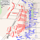
Gotta love battlefield maps. Was browsing an older book on Gettysburg today and fell upon this wonderful visual depiction of Pickett's Charge. Could not resist to take a shot of it with my phone.

Thought I'd share (click to make it bigger.)
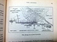
23877228325_e0272d816a_h.jpg
 

Attachments

  • 23877228325_e0272d816a_h.jpg
    23877228325_e0272d816a_h.jpg
    341.4 KB · Views: 132
I LOVE this map! It tells me where the regiments were posted on the Union side and how the Confederates were lined up by division. I never realized until now that the Emmitsburg Road actually crossed the field at an angle.

Do you remember what the name of the book was and the author? I'd like to get this one for my library, just to have that map!

Alan
 
That is probably one of the best map depictions of the charge that I have seen. None of the other many contemporary battle maps (with the possible exception of those in Earl J. Hess's book on the charge) provide as much clarity in an easily understood format. Interesting that the map designates the attack as "Longstreet's Charge."
 
I know so little about the nitti gritti fine points of the Gettysburg fight, but I DO think this map is a compelling and descriptive visual. I will accept it as accurate until someone comes along here and contests it. I doubt that will happen.
 
Indeed Emmitsburg Road is at an angle (albeit not that sharp at that point; more like 30 degrees vs the depicted 45) and indeed this is a very good map of most of the positions of the front line of the federal troops. Unfortunately there is a bit of epic fail on the edges, regarding 8th OH.

As far as the movement of troops = arrows (other than that of Stannard's VT regiments, which is close) is pure Science Fiction or Fantasy from the John Bachelder school :) And back then it was known as "Longstreet's Assault" (and usually a few epithets were preceding Longstreet.)

I can go back and check on the exact book next Saturday, if still interested; but I would not spent any $ on it. Check the misspelling of Richard Brooks Garnett's middle initial in the picture too...
 
I know so little about the nitti gritti fine points of the Gettysburg fight, but I DO think this map is a compelling and descriptive visual. I will accept it as accurate until someone comes along here and contests it. I doubt that will happen.

Got to tell you that it is not accurate regarding the Federal movements (see all of those arrows going to the copse of trees) and not accurate regarding Trimble's division. They never went in. The rest could be accurate, but would need to defy gravity and other mass laws, like 2 people simultaneously occupying the same space ;)
 
Got to tell you that it is not accurate regarding the Federal movements (see all of those arrows going to the copse of trees) and not accurate regarding Trimble's division. They never went in. The rest could be accurate, but would need to defy gravity and other mass laws, like 2 people simultaneously occupying the same space :wink:
Okay... There you have it! It's still a compelling visual. If inaccurate, I know it'll drive historians crazy!
 
I LOVE this map! It tells me where the regiments were posted on the Union side and how the Confederates were lined up by division. I never realized until now that the Emmitsburg Road actually crossed the field at an angle.

Do you remember what the name of the book was and the author? I'd like to get this one for my library, just to have that map!

Alan
Its a good map for visualizing the general flow of the charge, but certainly not exact. Some of Pettigrew's men shifted over to the breakthrough, but most were hitting the Federal line to the north of it.

This map by Hal Jespersen is probably a better example:
 

Attachments

  • Pickett's-Charge-detail.png
    Pickett's-Charge-detail.png
    252.8 KB · Views: 456
Indeed Emmitsburg Road is at an angle (albeit not that sharp at that point; more like 30 degrees vs the depicted 45) and indeed this is a very good map of most of the positions of the front line of the federal troops. Unfortunately there is a bit of epic fail on the edges, regarding 8th OH.


I can go back and check on the exact book next Saturday, if still interested; but I would not spent any $ on it. Check the misspelling of Richard Brooks Garnett's middle initial in the picture too...
Dunno how to tell you this...but...you misspelled Richard Brooke Garnett. I like the map as a broad-brush overview.
 

Learn About Us
About CivilWarTalk
Contact the Webmaster
Meet the Staff
Link to CivilWarTalk
Join Our Community
Register
Browse Forums
View Today's Discussions
Search the Forum
Get Help
FAQ
Student Guide
Forum Rules & Etiquette
Copyright / DMCA

     Contact Us CivilwarTalk on Facebook CivilWarTalk on YouTube CivilWarTalk on Twitter RSS Feed

Bringing the American Civil War and More to Life.
© 1999 - , CIVILWARTALK, LLC - Site Version 10.0

SlaveryTalk.com - SecessionTalk.com - CivilWarTalk.com - ReconstructionTalk.com
Back
Top