River Obstructions to protect Wilmington

Lisa Murphy

Corporal
Joined
Feb 16, 2019
Location
Washington State
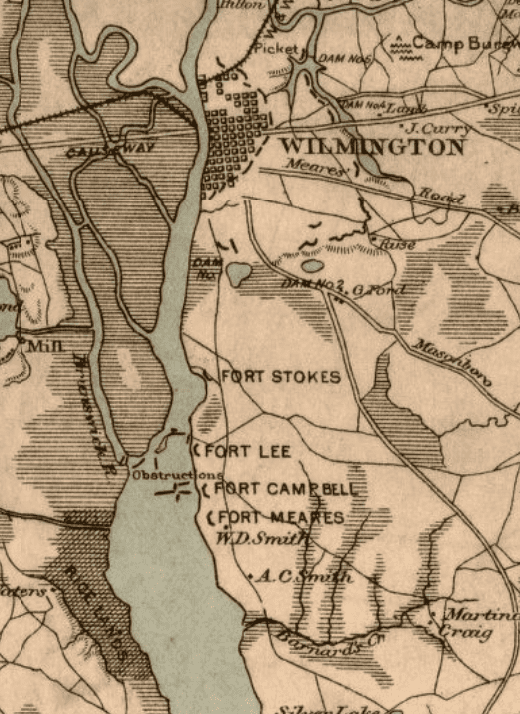
On a map of the Cape Fear River (Wilmington NC) from 1862, there are "river obstructions" in the river just south of Wilmington (see photos below). Does anyone know what those obstructions might have been, or how deep they were set? I would like to know how shallow a boat draft might need to be to pass over them. THANKS!

Full map: Map of the Cape Fear River and the approaches to Wilmington, N.C. : from C.S.A. Engineer Surveys

Cut sections of the map:
river obstructions2.PNG
River Obstructions.PNG
 
They could have been ships sunk on purpose. There are images of a few.

Supposed to be CSS Drury on the James but I've learned to mistrust labels.
sunk obstructiona css drury.jpg


Someone ID'd this one but I can't re-find the information. Guessing a shallow draft boat could pass over part of one of these, depending on size?
obstruction sunk.JPG
 
Obstructions took several forms, depending on local conditions and resources available. A quick way to make them was to sink ships in a line or blocking pattern. (The photos from JPK Huson are all from the James River, and I think don't show ships sunk as obstructions... for instance, one wouldn't normally leave a serviceable gun aboard a vessel about to be discarded.) Other ways were to drive in pilings (heavy logs driven into the bottom upright, obviously only practical if the water is relatively shallow), stringing a heavy chain across the channel (useful when the obstructions need to be opened periodically to allow friendly ships through), mines ("torpedoes"), or, frequently, a combination of several types.

I don't know the character of the obstructions in the Cape Fear off-hand, but I imagine one or more of Chris Fonvielle, Jr.'s books might mention them. The river couldn't have been completely obstructed before 1865, as blockade runners visited the city docks on a very frequent basis.
 
Ma'am, they might have been something like this - https://civilwartalk.com/threads/submerged-caissons-of-the-acw.150256/
25

HTHs,
USS ALASKA
1564085351503.png

YES! Here is your photo. And you cite a quote at that time confirming that these were the culprits. Thank you. Excellent.
So, how deep a draft a boat could pass would depend on the depth of the river at that point (the NOAA chart shows it as surprisingly shallow nowadays, 11-13 feet, but it may have been different then.) In any case, these caissons were likely big enough to present a barrier to most things except small boats. I am assuming that rowboats could get over...
 
Ma'am, as @Mark F. Jenkins posted above, the term 'obstructions' covers a multitude of hazards. An outstanding book, that covers more than what the title would suggest, is 'Infernal Machines' by Milton F. Perry - https://www.amazon.com/Infernal-Machines-Confederate-Submarine-Warfare/dp/0807112852/ref=sr_1_1?keywords='Infernal+Machines'+by+Milton+F.+Perry&qid=1564060803&s=gateway&sr=8-1

Cheers,
USS
Thank you! ordered a used copy. Will be an excellent resource. Looking forward to reading it.
 
Obstructions took several forms, depending on local conditions and resources available. A quick way to make them was to sink ships in a line or blocking pattern. (The photos from JPK Huson are all from the James River, and I think don't show ships sunk as obstructions... for instance, one wouldn't normally leave a serviceable gun aboard a vessel about to be discarded.) Other ways were to drive in pilings (heavy logs driven into the bottom upright, obviously only practical if the water is relatively shallow), stringing a heavy chain across the channel (useful when the obstructions need to be opened periodically to allow friendly ships through), mines ("torpedoes"), or, frequently, a combination of several types.

I don't know the character of the obstructions in the Cape Fear off-hand, but I imagine one or more of Chris Fonvielle, Jr.'s books might mention them. The river couldn't have been completely obstructed before 1865, as blockade runners visited the city docks on a very frequent basis.

Here (below) is what was quoted (USS ALASKA) last year. I remember reading about chains attached to trees across the Mississippi at Columbus Kentucky. And of course, the "Stone Fleet" sunk in Charleston Harbor.

If the obstructions placed on the map I am looking at are actually accurate (and not just symbolic representations) it looks as though there is a snaking path between them.

1564086596152.png
 
Yo! Cool. The attached information gives the dimensions as 17-3/8" H x 20-1/8" W. BIG. Mean.
So, the river had to be deeper then, or according to current NOAA maps these would be sticking several feet out of the water.
The drawing shows a river depth of 20 feet at high water at which time there would be 4 foot above the top of the sawyer. I don't know current river depths. I would imagine the height of the sawyer could be varied to suit the river depth.
 
The drawing shows a river depth of 20 feet at high water at which time there would be 4 foot above the top of the sawyer. I don't know current river depths. I would imagine the height of the sawyer could be varied to suit the river depth.
At 1:30 am on July 28th (low tide on the Cape Fear on the day in question) the river would drop 3 1/4 feet (according to this site), making the water a little less than 1 foot over the points. I am not enough of a navigator to know if, dropping 3 feet at the mouth of the river translates all the way up the river...?
 
Various ships were sunk in the Cape Fear River after the fall of Fort Fisher, but I believe the obstructions in question were alraedy there by 1864, with an opening for blockade runners and Confederate ships.

RoadDog
 
At 1:30 am on July 28th (low tide on the Cape Fear on the day in question) the river would drop 3 1/4 feet (according to this site), making the water a little less than 1 foot over the points. I am not enough of a navigator to know if, dropping 3 feet at the mouth of the river translates all the way up the river...?
Every river that meets the ocean has a point at which the fresh river water overpowers the salt sea water. This location moves up and down the river based on the amount of fresh water flowing outward (downstream after up stream rain storms, upstream during droughts in the catch basin) and the state of the tide. Most rivers have a stretch of river that changes from fully fresh to fully salt, with movement outside of that stretch being rare.

The tidial rise moves upriver with the incoming tide, but decreases the farther in you go. Tide table books will show this decrease in the effect of the incoming tide; it usually does not show an increase very far inland.
 
If the obstructions placed on the map I am looking at are actually accurate (and not just symbolic representations) it looks as though there is a snaking path between them.

Good observation. The obstacles worked in conjunction with the shore batteries shown. A ship would have to wend its way through the obstructions, presumably at low speed, prolonging its exposure to gunfire. If it was damaged or suffered casualties to key personnel, it might then run into an obstruction. The batteries would also hinder any attempt to clear the obstructions and open the channel. Meanwhile the channel was still usable by Confederate craft or blockade runners.

As often happens in military affairs, guns and obstacles in combination were more effective than either would have been alone.
 
I recall one incident where some sort of dispute about a blockade runner or her cargo caused the authorities to bring the ironclad North Carolina up the river from her usual anchorage at Smithville (present-day Southport) to the city docks. I'm trying to picture that lumbering beast picking her way through obstructions on the way... :confused: (@DaveBrt's post reminded me of that with the business about salt and fresh water. It has been said that if the ironclad had gone up river more often, it might have helped prevent the shipworm problem that eventually caused her sinking.)
 
Various ships were sunk in the Cape Fear River after the fall of Fort Fisher, but I believe the obstructions in question were alraedy there by 1864, with an opening for blockade runners and Confederate ships.

RoadDog
Yes, the map showing the obstructions (from the Library of Congress) says 1862.
 
Every river that meets the ocean has a point at which the fresh river water overpowers the salt sea water. This location moves up and down the river based on the amount of fresh water flowing outward (downstream after up stream rain storms, upstream during droughts in the catch basin) and the state of the tide. Most rivers have a stretch of river that changes from fully fresh to fully salt, with movement outside of that stretch being rare.

The tidial rise moves upriver with the incoming tide, but decreases the farther in you go. Tide table books will show this decrease in the effect of the incoming tide; it usually does not show an increase very far inland.

Thank you! The events I am writing about take place just 3 miles down from Wilmington -- quite a ways up the river. So I assume the tide would not drop 3+ feet, especially since there is a thunderstorm and heavy rains. So perhaps, realistically, little to no tidal change at the crucial moment?
 
Good observation. The obstacles worked in conjunction with the shore batteries shown. A ship would have to wend its way through the obstructions, presumably at low speed, prolonging its exposure to gunfire. If it was damaged or suffered casualties to key personnel, it might then run into an obstruction. The batteries would also hinder any attempt to clear the obstructions and open the channel. Meanwhile the channel was still usable by Confederate craft or blockade runners.

As often happens in military affairs, guns and obstacles in combination were more effective than either would have been alone.
All right. Great. Love it. What a trip through those barriers it would be for an enemy. This is fantastic.
 

Learn About Us
About CivilWarTalk
Contact the Webmaster
Meet the Staff
Link to CivilWarTalk
Join Our Community
Register
Browse Forums
View Today's Discussions
Search the Forum
Get Help
FAQ
Student Guide
Forum Rules & Etiquette
Copyright / DMCA

     Contact Us CivilwarTalk on Facebook CivilWarTalk on YouTube CivilWarTalk on Twitter RSS Feed

Bringing the American Civil War and More to Life.
© 1999 - , CIVILWARTALK, LLC - Site Version 10.0

SlaveryTalk.com - SecessionTalk.com - CivilWarTalk.com - ReconstructionTalk.com
Back
Top