Need help with a Gettysburg piece!

Joined
Oct 2, 2015
Hello there, I am in the process of finishing my largest piece of art work yet. However, I have hit a brick wall. The piece is the 5th Louisiana's assault on Cemetery Hill at dusk on july 2nd, 1863. I have completed all but the background, which is were I need some help. Below I have attached a map showing where they were at the time I am depicting them; also I have outlined the perspective of the "viewer" in lime green. I need period photos, if possible close to the area on the map, that depict the landscape looking north east from just north of cemetery hill. Basically, the land between Culps Hill and the Town as seen from cemetery hill. If any modern photos show the hills in the background looking northeast over the area, that would be nice as well. I have also attached a period photo which shows the left edge of the background I am trying to depict. The photo looks north, perpendicular t my subject, but I need a photo, even a period painting, that depicts a northeastern view. The closer to the perspective I have marked on the map the batter, but I can work with anything Im given. Thank you in advance!

Expired Image Removed
Expired Image Removed Expired Image Removed
 
Last edited:
I'm not sure you attached the map. I wonder if you missed that in your post.

I have a modern pic, very close to your location. But I'm guessing it is about 20-30 degrees too far east for what you want.
It would show where the NC troops under Avery passed.


Modern photos won't help much though. Where the 5th attacked now would be a big blue water tower, a parking lot full of double decker busses and 7 houses.

But here is a link to one painting and it's close to where the 5th attacked.https://npsgnmp.wordpress.com/2012/06/08/frankenstein/


and here is what I mean about the 'big blue' tower. But note there is one period photo in B&W that shows the exact area you want. I believe, just in front of the tents.
http://www.gettysburgdaily.com/elev...th-licensed-battlefield-guide-stuart-dempsey/

...also gives a dandy view of the football field. Which is nice...
 
Last edited:
I'm not sure you attached the map. I wonder if you missed that in your post.

I have a modern pic, very close to your location. But I'm guessing it is about 20-30 degrees too far east for what you want.
It would show where the NC troops under Avery passed.

Ill take the picture, its not too far as long as culps hill isnt in it. Indeed I posted the picture I m drawing instead of the map, Ill fix that. thank you.
 
Perhaps @pamc153PA could help you out with this more than I can.

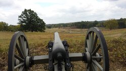
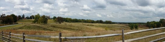
Sorry but this is about the best I have. Took these on East Cemetery Hill during my last visit several years ago, although they're looking out more toward where Avery's Brigade attacked. The western side of the hill where Hays' Louisianians made their advance is now somewhat covered by trees and, as I recall, has some modern structures in the way. I remember that the trees sort of obstructed the view there, hence no pics from that area, i.e. the northwestern slope of East Cemetery Hill.

First image was taken from where either Ricketts' or Reynolds' battery was positioned, facing northeast. Second is a panorama looking west with Cemetery Hill to the left, though that's more so where Avery's Brigade was. As you can see, the ground over which the 1st Louisiana Brigade made their assault is now pretty much obstructed by trees.
 

Attachments

  • gettysburg 142.jpg
    gettysburg 142.jpg
    276.3 KB · Views: 187
  • gettysburg 138.jpg
    gettysburg 138.jpg
    122.8 KB · Views: 192
Last edited:
Perhaps @pamc153PA could help you out with this more than I can.

Sorry but this is about the best I have. Took these on East Cemetery Hill during my last visit several years ago, although they're looking out more toward where Avery's Brigade attacked. The western side of the hill where Hays' Louisianians made their advance is now somewhat covered by trees and, as I recall, has some modern structures in the way. I remember that the trees sort of obstructed the view there, hence no pics from that area, i.e. the northwestern slope of East Cemetery Hill.

First image was taken from where either Ricketts' or Reynolds' battery was positioned, facing northeast. Second is a panorama looking west with Cemetery Hill to the left, though that's more so where Avery's Brigade was. As you can see, the ground over which the 1st Louisiana Brigade made their assault is now pretty much obstructed by trees.

Very nice, these pictures are of some assistance Thank you very much. Indeed, there were some trees were Hays Brigade made their assault, but there are many more now. Also I believe the exact position I am depicting the 5th at is now part of the foundation for a high school.
 
Ill take the picture, its not too far as long as culps hill isnt in it. Indeed I posted the picture I m drawing instead of the map, Ill fix that. thank you.

In this not so color balanced photo (my camera is defective) the German Reformed church is behind the Fence post on the very left. That is the area you mentioned. Between Culps hill and the town. In other words Culps Meadow. (culps hill is way right, and Mencheys Spring out of the picture far left.
Expired Image Removed
 
  • Like
Reactions: AUG
Thank you all, but most of these Ive seen. That painting shows the very western edge of what Im looking for. Also, if you take another look, the battle flag does have "waves" in it. I as drawing it from a picture of reenactors, and I drew its folds just as it appeared in the picture. Its not just a blank square. Vriginia Worm, your picture will be of much help, thank you.
 
thank you for that link to the period photos, it shows enough of the horizon for me to scratch out a back ground. Its unfortunate photography was so primitive at the time, it very hard to make out the hills.
 

Learn About Us
About CivilWarTalk
Contact the Webmaster
Meet the Staff
Link to CivilWarTalk
Join Our Community
Register
Browse Forums
View Today's Discussions
Search the Forum
Get Help
FAQ
Student Guide
Forum Rules & Etiquette
Copyright / DMCA

     Contact Us CivilwarTalk on Facebook CivilWarTalk on YouTube CivilWarTalk on Twitter RSS Feed

Bringing the American Civil War and More to Life.
© 1999 - , CIVILWARTALK, LLC - Site Version 10.0

SlaveryTalk.com - SecessionTalk.com - CivilWarTalk.com - ReconstructionTalk.com
Back
Top