Illegible Map Content 1907

Joined
Aug 25, 2017
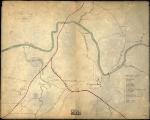
There are three textual references in this map that I was hoping some fellow members could discern.

The red lines indicates rail lines. Due south of where the rail lines cross the river are three textual remarks form the map maker. I am unable to read these.

It looks like the top reference states "Old Quarter", but I am total loss for the other two.

Anyone?


Will need to click the image a couple of times to get full resolution.
Library_of_Congress.jpg
 

Attachments

  • Library_of_Congress.jpg
    Library_of_Congress.jpg
    135.7 KB · Views: 112
I'm sorry, but this is simply not high enough resolution to read. Can you post a link to the original at LoC?

I found a higher-resoultion version here, but still not clear enough to read:

Tennessee-Columbia.jpg
 
Thanks Andy!

What do these terms mean exactly and do you think the area would have been populated with trees?

"Quarters" was a term used for communal areas (groups of cabins) used for enslaved plantation or farm laborers.

I don't know about the trees. Your best best there would be to consult a map of the area from the OR Atlas, that may give that information.
 

Learn About Us
About CivilWarTalk
Contact the Webmaster
Meet the Staff
Link to CivilWarTalk
Join Our Community
Register
Browse Forums
View Today's Discussions
Search the Forum
Get Help
FAQ
Student Guide
Forum Rules & Etiquette
Copyright / DMCA

     Contact Us CivilwarTalk on Facebook CivilWarTalk on YouTube CivilWarTalk on Twitter RSS Feed

Bringing the American Civil War and More to Life.
© 1999 - , CIVILWARTALK, LLC - Site Version 10.0

SlaveryTalk.com - SecessionTalk.com - CivilWarTalk.com - ReconstructionTalk.com
Back
Top