lelliott19
Brigadier General
★ Moderator
* OFFICIAL *
CWT PRESENTER
CWT PRESENTER
Silver Patron
Regtl. Staff Chickamauga 2018
- Joined
- Mar 15, 2013
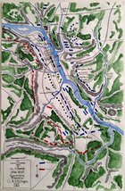
I was reading OReilly's 'Winter War on the Rappahannock' and ran across this on page 73:
"At 11:00 AM the lower pontoon crossing was ready for Franklin's Left Grand Division. Robertson's Confederate brigade had yielded all the ground between the river and the Bowling Green Road, and Colonel Luse's 18th Mississippi faced the ominous prospect of being flanked as soon as the Federals crossed. Seeing this danger, Confederate general Lafayette McLaws forwarded two regiments to reinforce Luse's precarious line. Colonel William D. DeSaussure's 15th South Carolina and Colonel Goode Bryan's 16th Georgia hurried down a farm lane from John Howison's house, Braehead, to the Ferneybough house.
DeSaussure's South Carolinians formed on the right of Luse's 18th Mississippi and rested their flank on the Bowling Green Road at Deep Run. Bryan moved the 16th Georgia to the left of the Mississippians and extended their line along Deep Run to the river. The 15th South Carolina sent three companies to skirmish in front. Bryan's Georgians, on the other hand, concentrated and suffered severe artillery fire. A Georgia soldier recalled, "We had a pretty rough experience." Major James S. Gholston asked Lieutenant Colonel Henry P. Thomas, "Colonel, what will we do in a case of this kind?" Thomas replied, "Well, I don't see we are hurt so very much as yet." The men disagreed and jumped into the Deep Run ravine for cover. General Joseph Kershaw visited the position and agreed with the men. He ordered all three regiments to the Bowling Green Road for protection. General Barksdale heard of the withdrawal and flew to the site. The general demanded that the 18th Mississippi "must not recede another inch." Barksdale and Kershaw agreed to hold the road but no one could stop the Union Left Grand Division from crossing."
I've never seen this information before and was wondering if someone who is good with maps could mark up a map to illustrate the locations referenced here in relation to landmarks? I know where Braehead is. I know where the stone wall is and Marye's Heights. And I know where the river is and downtown. Other than that I am lost. Not being familiar with the area, it sounds to me like the 16th GA, 18th MS, and 15th SC were making a circle") beginning and ending at Deep Run and I know that cant be the case. Thanks for any help.
beginning and ending at Deep Run and I know that cant be the case. Thanks for any help.
"At 11:00 AM the lower pontoon crossing was ready for Franklin's Left Grand Division. Robertson's Confederate brigade had yielded all the ground between the river and the Bowling Green Road, and Colonel Luse's 18th Mississippi faced the ominous prospect of being flanked as soon as the Federals crossed. Seeing this danger, Confederate general Lafayette McLaws forwarded two regiments to reinforce Luse's precarious line. Colonel William D. DeSaussure's 15th South Carolina and Colonel Goode Bryan's 16th Georgia hurried down a farm lane from John Howison's house, Braehead, to the Ferneybough house.
DeSaussure's South Carolinians formed on the right of Luse's 18th Mississippi and rested their flank on the Bowling Green Road at Deep Run. Bryan moved the 16th Georgia to the left of the Mississippians and extended their line along Deep Run to the river. The 15th South Carolina sent three companies to skirmish in front. Bryan's Georgians, on the other hand, concentrated and suffered severe artillery fire. A Georgia soldier recalled, "We had a pretty rough experience." Major James S. Gholston asked Lieutenant Colonel Henry P. Thomas, "Colonel, what will we do in a case of this kind?" Thomas replied, "Well, I don't see we are hurt so very much as yet." The men disagreed and jumped into the Deep Run ravine for cover. General Joseph Kershaw visited the position and agreed with the men. He ordered all three regiments to the Bowling Green Road for protection. General Barksdale heard of the withdrawal and flew to the site. The general demanded that the 18th Mississippi "must not recede another inch." Barksdale and Kershaw agreed to hold the road but no one could stop the Union Left Grand Division from crossing."
I've never seen this information before and was wondering if someone who is good with maps could mark up a map to illustrate the locations referenced here in relation to landmarks? I know where Braehead is. I know where the stone wall is and Marye's Heights. And I know where the river is and downtown. Other than that I am lost. Not being familiar with the area, it sounds to me like the 16th GA, 18th MS, and 15th SC were making a circle
beginning and ending at Deep Run and I know that cant be the case. Thanks for any help.