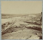
A Bridge Across Tennessee River question

Mike Serpa

Lt. Colonel
Joined
Jan 24, 2013
Bridge across Tennessee River built by troops. NARA #526239
526239a.jpg


Army bridge across the Tennessee River at Chattanooga. LOC #33482
33482v.jpg


Below photo from "The photographic history of the Civil War : thousands of scenes photographed 1861-65"
Screen Shot 2016-03-08 at 6.09.43 PM.png


Why was "the draw" built so close to the river bank? Just the way bridges were built at that time? Faster, easier, cheaper? If for loading, unloading boats or for boats to pass by wouldn't the water be too shallow so close to the bank? Etc.
 
I would hazard a guess that the presence of at least three boats up against the shore indicates that the water was plenty deep enough for them. Further, that riverboats were notorious for bashing into bridge pilings so setting the draw out toward the middle would (a) increase the likelihood of damage which would (b) be more difficult to repair. The location indicates the vessels "wanted" to be there and therefore moving into and away from the moorings past the bridge would be a simple straight shot down along the bank.
 
Thanks for posting a bridge! Love this one, no idea why. Geek, maybe. The engineers laid such amazing paths through the war- for the armies to blow up, then they'd build more.

This the same one taken from the left, too? Always has looked so 'Lincoln-Logs', and kind of delightful because it does, you should forgive the association. There are a few from the left, if it's the same bridge, photographer must have had a fascination with this structure. I'm sorry to be boring but can see why? Those engineers must have been amazing. All those troops swarming this thing, everyone knew what they were doing- poof, a bridge.

Bridge across the Cumberland at Chattanooga.jpg


bridge tennessee.jpg

This is the one which always seems so ' Lincoln Logs ', like it was kind of glued together, men swarming the thing like ants.

Isn't that a terrific set of books Mike? Have a few from the old set- Ebay!
 
Why was "the draw" built so close to the river bank? Just the way bridges were built at that time? Faster, easier, cheaper? If for loading, unloading boats or for boats to pass by wouldn't the water be too shallow so close to the bank? Etc.

Excellent question!
I have had a quick look and found out that draw bridge engineering has made a great progress during the second half oth the 19th century. Maybe at the time the bridge was built there was not enough knowledge to construct the opening in the middle of such a long bridge ... the counterweight might have been a problem:

upload_2016-3-9_12-11-23.png

http://www.encyclopedia.com/doc/1G2-2897000040.html

But that is just a wild guess. Probably someone else will be able to contribute something more substantial.
I just wanted to find out a bit because I always like questions like these I would never have thought about all by myself.
 
Bridge across Tennessee River built by troops. NARA #526239
View attachment 94240

Army bridge across the Tennessee River at Chattanooga. LOC #33482
View attachment 94241

Below photo from "The photographic history of the Civil War : thousands of scenes photographed 1861-65"
View attachment 94242

Why was "the draw" built so close to the river bank? Just the way bridges were built at that time? Faster, easier, cheaper? If for loading, unloading boats or for boats to pass by wouldn't the water be too shallow so close to the bank? Etc.
Many rivers have a deep channel next to one bank, with the rest of the river being much more shallow, to the point of having marshes and small islands in the river (Appomattox River in Petersburg). The depth of the channel may be determined by the composition of the banks (a rock bank on one side would usually have the deep channel if the other bank was soft and easily eroded) and by the direction of the water flow as it arrived at the spot -- a southbound river the makes a sharp turn to west (and maybe on back to north) would scour the main channel close to the south end of the river (ie where the river hit the bank and was turned to a new direction). Combine the bank composition and the river direction and you can get deep water right next to a bank.
 
I would hazard a guess that the presence of at least three boats up against the shore indicates that the water was plenty deep enough for them. Further, that riverboats were notorious for bashing into bridge pilings so setting the draw out toward the middle would (a) increase the likelihood of damage which would (b) be more difficult to repair. The location indicates the vessels "wanted" to be there and therefore moving into and away from the moorings past the bridge would be a simple straight shot down along the bank.
Very good observation!

Thanks for posting a bridge! Love this one, no idea why. Geek, maybe. The engineers laid such amazing paths through the war- for the armies to blow up, then they'd build more.

This the same one taken from the left, too? Always has looked so 'Lincoln-Logs', and kind of delightful because it does, you should forgive the association. There are a few from the left, if it's the same bridge, photographer must have had a fascination with this structure. I'm sorry to be boring but can see why? Those engineers must have been amazing. All those troops swarming this thing, everyone knew what they were doing- poof, a bridge.

View attachment 94254

View attachment 94255
This is the one which always seems so ' Lincoln Logs ', like it was kind of glued together, men swarming the thing like ants.

Isn't that a terrific set of books Mike? Have a few from the old set- Ebay!
Nice photos. As always! I have the entire set on my computer.

Excellent question!
I have had a quick look and found out that draw bridge engineering has made a great progress during the second half oth the 19th century. Maybe at the time the bridge was built there was not enough knowledge to construct the opening in the middle of such a long bridge ... the counterweight might have been a problem:

View attachment 94256
http://www.encyclopedia.com/doc/1G2-2897000040.html

But that is just a wild guess. Probably someone else will be able to contribute something more substantial.
I just wanted to find out a bit because I always like questions like these I would never have thought about all by myself.
You seem more interested in the mechanics than I am!

Many rivers have a deep channel next to one bank, with the rest of the river being much more shallow, to the point of having marshes and small islands in the river (Appomattox River in Petersburg). The depth of the channel may be determined by the composition of the banks (a rock bank on one side would usually have the deep channel if the other bank was soft and easily eroded) and by the direction of the water flow as it arrived at the spot -- a southbound river the makes a sharp turn to west (and maybe on back to north) would scour the main channel close to the south end of the river (ie where the river hit the bank and was turned to a new direction). Combine the bank composition and the river direction and you can get deep water right next to a bank.
Thanks for this information. The only thing I know about rivers is they follow the path of least resistance.
 
Excellent question!
I have had a quick look and found out that draw bridge engineering has made a great progress during the second half oth the 19th century. Maybe at the time the bridge was built there was not enough knowledge to construct the opening in the middle of such a long bridge ... the counterweight might have been a problem:

View attachment 94256
http://www.encyclopedia.com/doc/1G2-2897000040.html

But that is just a wild guess. Probably someone else will be able to contribute something more substantial.
I just wanted to find out a bit because I always like questions like these I would never have thought about all by myself.
There is no visible bascule, at least that I can see on this bridge. There is reinforcement of the attached sections for the drawing mechanisms. The placement of the draw could be subject to many factors such as depth, water speed, current problems, possible impediments in the water, perhaps even the proximity to where those ships would dock etc. My greatest suspicion is that it has to do with current speed and control of the boats through narrow trestles. I'd love to see the study done by the designing Engineer that caused this plan to happen. The data would be very interesting. BTW- Fantastic pictures.
 
If it's this bridge (center) at the base of Cameron Hill, the point on the south side, being on the inside of the bend, might have had a slower current than the middle of the river or the other bank. That would make navigating a narrow opening a little easier.

5281333120_36f6b35ed0_o.jpg
 
Last edited:
If it's this bridge (center) at the base of Cameron Hill, the point on the south side, being on the inside of the bend, might have had a slower current than the middle of the river or the other bank. That would make navigating a narrow opening a little easier.

View attachment 94311
That would seem to be consistent with the geography in the image too. The topo map seems to match well. Nice detective work AndyHall. I might add that the docks for the city would also be on that side too.
 
Ha! It's like trolling for engineers, asking questions like that, thank you Mike Serpa, please continue! I only know enough to stay interested despite being fascinated. Something wrong there. Still- this ' thing ' where the entire war played out on a background , what's a word- pre-prepared? OH. Duh. Engineered, by the engineers flattens me, no idea why. Toilets flushing up in ships, pontoons bridges slapped together for whole army's escape or while the engineers are being picked off one by one, a river forced into coughing up a fleet. Geesh. This bridge- looks like a middle school toothpick project, did the job. OH, all-time favorite, pontoon bridge on North Anna, hysterical, 2 pontoons. Sorry, off thread. Just keep trolling. They will come.
 
View attachment 94326
Here's the LoC ( and National Archives ) image used in the book, knew I had it somewhere.

View attachment 94327
Awesome images! I think we have hit on the location too. If you look to the right you see what appears to be an island in the distance. Comparing that to the topo map it would seem to be an excellent fit to Chattanooga Is. The bridge would seem to be the one mentioned above by AndyHall. I would also suggest that the current on the inside of that bend would be most navigable and that the city docks would be a tough go if the draw was further away from them, out in the middle of that bridge. The draw makes much better sense near the shore there.
 
"Army Bridge, Chattanooga, 1864," from LoC. This doesn't exactly square with the position of the bridge shown on the map; this puts it farther upstream, closer to town.

35067v.jpg
 

Attachments

  • 35067v.jpg
    35067v.jpg
    169.2 KB · Views: 60

Learn About Us
►About CivilWarTalk
►Contact the Webmaster
►Meet the Staff
►Link to CivilWarTalk
Join Our Community
►Register
►Browse Forums
►View Today's Discussions
►Search the Forum
Get Help
►FAQ
►Student Guide
►Forum Rules & Etiquette
►Copyright / DMCA

     Contact Us CivilwarTalk on Facebook CivilWarTalk on YouTube CivilWarTalk on Twitter RSS Feed

Bringing the American Civil War and More to Life.
© 1999 - , CIVILWARTALK, LLC - Site Version 10.0

SlaveryTalk.com - SecessionTalk.com - CivilWarTalk.com - ReconstructionTalk.com
Back
Top