Civil War maps

Bryce

Sergeant
Joined
Jun 2, 2011
Location
Washington, D.C.
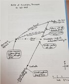
I didn't really grasp the progress of the siege of Petersburg until I acquired a copy of "in the trenches at Petersburg" by Earl Hess. Until that time I had available to me only several books on the particular battles of the siege, but I didn't understand how the union Army kept moving Westward thus forcing the confederates to extend their lines further and further West.

I'd like to offer to share those maps with any of you who are interested. All you need to do is email me and I'll send you photographs of the maps.

Bryce
[email protected]
 
Sgttallcorn reporting after extended AWOL.

Living in Sweetwater, TN, between Chattanooga and Knoxville, I've been able to find tons of stuff that happened in the area.

One of such was the Battle of Philadelphia, 20 October 1863. Philadelphia is the next town north on US 11 ( Old Lee Highway) from Sweetwater. I've read a actual field reports from the Union command and a few from the Confederate command. In one such report I read about "Federal Hill" and so I've been looking for that hill for the last few months. There really isn't anybody here that I've got to know that really doesn't know of very much to recall. So one day, I happened by the Sweetwater library and asked if they had any information on Philadelphia. This is how I found this book that the Sweetwater library let me take pictures of what I found. May I present - The Battle Of Philadelphia.

20250904_131228[1].jpg


20250904_131250[1].jpg


20250904_131317[1].jpg


20250904_131330[1].jpg


20250904_131340[1].jpg
 
Continued - Battle of Philadelphia:
photo 3 - hand drawn map recounting battle (should be photo 1 but I seem to have trouble with this file)
photo 1 - Historical plaque in the town of Philadelphia, TN.

Answer to question "where is Federal Hill?"

The answer was right under my nose - there is a Battle of Philadelphia historical plaque - photo 2 - that explains the battle as well as stating to the reader that "...according to local tradition was on Federal Hill in front of you..."

Another historical marker - photo 2 - on the same street is 1F 28 - Affair in Philadelphia - matches the book:

"Here, in the cavalry action following the Battle of Chickamauga, the Confederate cavalry regiments of Dibrell and Morrison attacked Wolford's cavalry brigade, captured 700 prisoners, 6 mountain howitzers, 50 wagons loaded with stores, 10 ambulances and a quantity of horses and mules. The Federal survivors fled to Loudon. Personnel casualties were small."

20250910_112807[1].jpg


Affair in Philadelphia.jpg
 

Attachments

  • Battle of Philadelphia - 2.jpg
    Battle of Philadelphia - 2.jpg
    58.3 KB · Views: 27
This posted twice yesterday. I deleted the dupe. Sorry - Spectrum, you know....
 
Last edited:
Thanks for sharing— I've never heard of this battles. There are a lot of sites in W. Tenn and N. Miss of cavalry battles and skirmishes. Several were also fought in October 1863.
I have heard of Dibrell. I think he commanded a Tennessee cavalry regiment but he was led a brigade at this battle. I saw the name Adams and wondered who he was. I found it in the text: Silas Adams of 1st Kentucky Cavalry.

Did the Confederates have any artillery??
That will be my next rabbit hole to go down. I want to determine type and distances from both sides and then go metal detecting!

For those of you in the area it's northeast on 11 on the east side of Philadelphia. (Or 153 degree compass heading from the plaque in downtown Philadelphia.)

I've told my wife every time we drive by it: "if I was a commander, that's where I'd put my guns" and **** if I wasn't right!

More later!
 
Last edited:
Here's some of the battle reports that have been transcribed to the documents in these photos.

Photo Document 1 - Union report 5 days prior to battle
Photo Document 2 - Confederate report 2 days after to battle

(I probably found these by using one of the burrowing links on this entire CivilWarTalk Forum)

Scrimishes at Philadelphia 1863 -1.jpg


Scrimishes at Philadelphia 1863 -2.jpg
 
More -

From the Battle plaque in the town of Philadelphia:

"Colonels Dibrell and Morrison attacked the enemy in force at Philadelphia and captured 700 prisoners, 50 wagons loaded with stores, 6 pieces of artillery, 10 ambulances, and a lot of horses, mules, and other property." — Adjutant General George W. Brent

(sidebar on plaque)

The mountain howitzer was a short-barreled, large caliber cannon designed on a small scale so that pack animals could transport it. It was ideal for fast-moving cavalry units. The guns could go anywhere the horses and mules could go and were light enough for soldiers to move forward by hand during a fight. Two of the six mountain howitzers captured at the Battle of Philadelphia are in private collections

So now we can find the look for "Civil War Mountain Howitzer" and we find:

The standard Civil War M1841 mountain howitzer had an effective firing range of about 1,000 yards (919 meters). Its range was significantly shorter than other artillery pieces of the era due to its small size and short barrel, which were necessary for mobility in rough terrain.
Range limitations by ammunition type:

  • Spherical case shot: This anti-personnel round, packed with musket balls, could be fired to a distance of approximately 700 to 900 yards. The fuse was set to detonate the charge in the air over enemy troops.
  • Canister shot: Essentially a giant shotgun shell, canister rounds were used at close range. They were most effective against infantry at ranges of 400 yards or less.
  • Explosive shell: When firing a standard shell, the range was about 1,005 yards at a 5-degree elevation, with a half-pound black powder charge.
Despite its short range, the mountain howitzer's portability made it valuable for mountain troops and cavalry, especially when deployed to areas inaccessible to heavier field artillery.

Below is a map of current day Philadelphia. Using coordinates looking out from the plaque, the dot in the middle of the red circle is "Federal Hill". The red ring around that is the approximate range of a Mountain Howitzer, 6 used and later abandoned by Wolford until his ammo ran low and he declared "every man for himself". Within the parameter of the red ring I next need to determine from the hand drawn map exactly where the Confederate guns were placed and then start metal detecting - both on Federal Hill and the areas to the northeast and southwest headings on the ring. The only way into the area was on Old Lee Highway and Morrison's force came down it and Dibrill came up it.

More later -

1758073646528.png

1758075141561.png
 
Last edited:

Learn About Us
About CivilWarTalk
Contact the Webmaster
Meet the Staff
Link to CivilWarTalk
Join Our Community
Register
Browse Forums
View Today's Discussions
Search the Forum
Get Help
FAQ
Student Guide
Forum Rules & Etiquette
Copyright / DMCA

     Contact Us CivilwarTalk on Facebook CivilWarTalk on YouTube CivilWarTalk on Twitter RSS Feed

Bringing the American Civil War and More to Life.
© 1999 - , CIVILWARTALK, LLC - Site Version 10.0

SlaveryTalk.com - SecessionTalk.com - CivilWarTalk.com - ReconstructionTalk.com
Back
Top